Publication select ▼
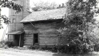
Businesses line northbound Van Dyke Avenue, north of 18 1/2 Mile road. City officials recently discussed the importance of planning for developments, particularly in strategic districts such as the North Van Dyke corridor.
Photo by Patricia O’Blenes

STERLING HEIGHTS — Planning about planning was the focus of discussion at a special meeting among Sterling Heights officials over the direction of how the city’s land will be used in the future.
Members of the Sterling Heights City Council, administration, Planning Commission and Zoning Board of Appeals shared ideas and discussed the city’s master plan, zoning and related issues during a special May 9 meeting.
Mayor Michael Taylor said the meeting’s purpose was to get officials on the same page as the city progresses toward its next master planning process.
City Manager Mark Vanderpool said the master land use plan is a “guiding light” for future city development. He said it’s important to stay focused on the city’s current master plan, which he said was formed in 2017, while “we’re getting to the next level.”
He stressed the importance of getting things right, adding that without long-term planning, the city risks passively sitting on the sidelines.
Vanderpool said the city has spent years planning for the Lakeside Mall area’s redevelopment, and he called attention to other commercial corridors along Mound Road, Van Dyke Avenue, M-59 and more.
“We get this one chance, because in the past, you know, 20, 30 years ago, when we had vast amounts of green space, it was OK if we didn’t always hit it perfectly, because we … would have a second or third chance,” Vanderpool said. “But we don’t have that, now being fully built out. So the wrong use in the wrong place can set the master plan back by decades.”
City planning officials and experts gave presentations that covered the master plan’s role and application, the dangers of deviating from it, and the next steps with moving forward.
Giffels Webster planning consultant Andy Aamodt said master plans are supposed to be reviewed every five years. He called the master plan the city’s “blueprint for the future,” which typically sets goals and objectives for a decade or two ahead. He explained that the master plan’s long-term guidance can influence the city’s zoning ordinance and its regulations.
City Planner II Alexis Richards warned that the master plan can become “blurred” if zoning ordinances don’t reflect changes over time in the master plan’s vision. Also, all decision-making bodies must consider the master plan when looking at development proposals, she said.
“Variances, specifically use variances, should be rare to ensure that we are sticking with the vision that is outlined within the master plan,” she added.
Assistant City Planner Jake Parcell said the city needs to balance new developments with the needs of residents and business owners who already live or operate in the city. He also called attention to land use efficiency, adding that some of the city’s key development “nodes,” typically located around critical intersections, have ample parking that isn’t used.
“A lot of parking can be underutilized, and one way to help that out is through landscaping as well,” he said. “So with our master land use plan moving forward, we’re placing an emphasis on the tree canopy, improving our landscaping and signage to help all the businesses make sure that they’re visible from the roadways, and finding opportunities for them to locate in these nodes.”
Parcell also spoke about the changing market demand for certain types of property. He explained that office demand has in some ways decreased since the COVID-19 pandemic, and he also addressed an increased demand for housing.
“As we see in most of our City Council meetings, people want to live in Sterling Heights, and we need to make sure that we have a market available for people to move here,” he said.
He concluded by saying that Sterling Heights needs to prioritize thoughtful, intentional development within its nodes. He also said the North Van Dyke Avenue corridor — from around 18 1/2 Mile Road to south of M-59 — needs landscaping and welcoming public gathering areas.
Afterward, officials continued to discuss how the landscape has changed with demand for different types of property. Planning Commissioner Gerald Rowe explained the need to revitalize “tired” shopping centers to either “make them more viable” or adapt their use.
Rowe also addressed a recent decrease in demand for offices.
“Perhaps there’s an opportunity for adaptive reuse of these buildings, whether it’s residential or a different type of commercial or institutional kinds of uses,” he said.
Mixed-use districts, which combine residential with other uses such as commercial, were another popular discussion topic. Councilman Michael Radtke talked about the guidelines that he felt should be in place for mixed-use districts.
“I think they have the most potential in our city to really be transformative, but they’re going to require strict design standards to be successful, because right now, our zoning ordinance is kind of silent on how they’re supposed to develop,” he said.
Radtke suggested some examples of possible regulations.
“In the mixed-use zones, we need to ban things like car washes, dealerships, gas stations, drive-thrus — businesses that are solely based upon the automobile,” he said.
Learn more about Sterling Heights by visiting www.sterling-heights.net or by calling (586) 446-2489.
You May Also Be Interested In